Looks good, but the only problem I have is the scale.
It is too small.
About 10 times too small on a quick scaling of the map.
The scale tops out at 20 LY, but if you look at the map, and measure the federation using that scale (lower right corner of the map), then the Federation territory is definitly not 8000-10 000 LY across, as is mentioned in TNG (canon source).
How far away is the Romulan Neutral Zone from Earth?
-
Mr. Oragahn

- Admiral
- Posts: 6865
- Joined: Sun Dec 03, 2006 11:58 am
- Location: Paradise Mountain
-
Jedi Master Spock
- Site Admin
- Posts: 2164
- Joined: Mon Aug 14, 2006 8:26 pm
- Contact:
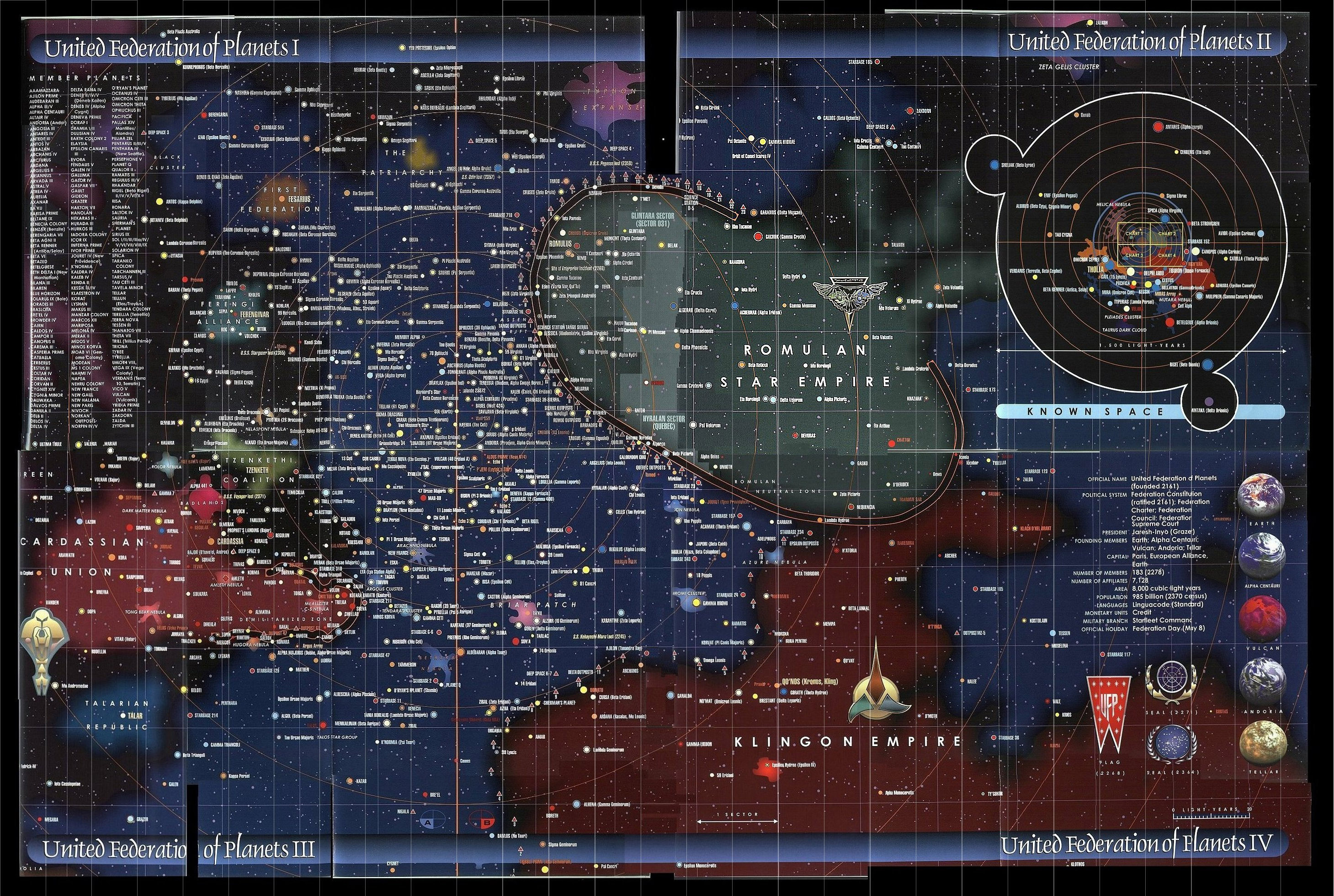
Looking at that map once again, I see there are numbers and what those numbers are. Having resolved that, I am now kicking myself for not realizing there's an obvious and specific scale on that chart.Mike DiCenso wrote: Right, but you miss the point of using BoBW here; it is a known time that it took to get from one of the fringe areas of Federation space back to Earth over a fairly known time period of up to 6 days (which also included a few stops along the way there, but for our conservative purposes it will be used as though the E-D and the Borg cube never stopped at all). So a known time to get back from the edge of Federation space. Is the Federation uniform enough to allow us to do this? Not really as shown in this canon map:
http://www.st-v-sw.net/photo312c.JPG
Ok, see the markers running from 342 to 354? Which are radial line segments pointing towards the center of the galaxy? That's degrees in galactic coordinates. Why the radial zero line is outside Federation territory proper is curious, of course, but with our system being ~26,000 LY from the galactic core and the map showing boxes over 12 degrees of arc, that's a ~5400 LY arc on Sol's latitude.
Drawing a line from the furthest points within the boxes is going to give us very close to 8,000 light years, reconfirming the explicit FC figure as well as telling us that the map is definitely of territory containing Federation planets.
And from there, we can try to draw up some distances, but IIRC, the chart does have some known problems for known stars, and the perspective can be tricky.
-
Mike DiCenso
- Security Officer
- Posts: 5837
- Joined: Fri Aug 18, 2006 8:49 pm
No, that's another thread since WILGA had another purpose in mind when he created this thread.Mr. Oragahn wrote:
I'm lost. Is there and Endor trip discussion going here as well??
It's a scanning of one of the maps from Geoffrey Mandel's superb, but mostly non-canon "Star Trek Maps" book.Mr. Oragahn wrote:Anyway, what do you think of that Trek map:
http://www.civfanatics.net/uploads9/Star_trek_map2.jpg
-Mike
-
Mike DiCenso
- Security Officer
- Posts: 5837
- Joined: Fri Aug 18, 2006 8:49 pm
If we went by the map, it would be at least a couple thousand light years to Romulan territory.
Is this a perfect map? As JMS has pointed out, there are problems with it, most notably the perspective. However it does give us a good idea of the Federation's "structure". Certainly we can guess that the UFP has a depth of up to 1,000 ly. The distance between Vulcan and Sol is off, though; ST:ENT's "Home" [S4] established clearly that Vulcan is some 16 light years from Earth. On the other hand, The UFP is at least 800 ly wide given that Rigel (assuming that Rigel is the star, not just the name of a planet') falls well within it's boundries. Just using that as a bench mark, the UFP is at least some 4,800 x 6,000 ly.
-Mike
-
Praeothmin

- Jedi Master
- Posts: 3920
- Joined: Mon Oct 23, 2006 10:24 pm
- Location: Quebec City
-
Jedi Master Spock
- Site Admin
- Posts: 2164
- Joined: Mon Aug 14, 2006 8:26 pm
- Contact:
Vulcan has traditionally been guessed as orbiting 40 Eridani A; there are shipyards located there, and that's about the only star fitting the descriptions given. In this case, ENT's geography seems to be accurate to the other data about Vulcan.Mike DiCenso wrote:If we went by the map, it would be at least a couple thousand light years to Romulan territory.
Is this a perfect map? As JMS has pointed out, there are problems with it, most notably the perspective. However it does give us a good idea of the Federation's "structure". Certainly we can guess that the UFP has a depth of up to 1,000 ly. The distance between Vulcan and Sol is off, though; ST:ENT's "Home" [S4] established clearly that Vulcan is some 16 light years from Earth. On the other hand, The UFP is at least 800 ly wide given that Rigel (assuming that Rigel is the star, not just the name of a planet') falls well within it's boundries. Just using that as a bench mark, the UFP is at least some 4,800 x 6,000 ly.
-Mike
Rigel and Deneb are both canonically in Federation territory as of TOS, although Deneb seemed to be near the frontier. Rigel has numerous issues, of course, mostly related to "Broken Bow," whose internal inconsistencies have been discussed.
-
Mike DiCenso
- Security Officer
- Posts: 5837
- Joined: Fri Aug 18, 2006 8:49 pm
-
Jedi Master Spock
- Site Admin
- Posts: 2164
- Joined: Mon Aug 14, 2006 8:26 pm
- Contact:
Well, Rigel X has a very similar designation to all the other Rigel planets (Rigel II, Rigel XII, et cetera).Mike DiCenso wrote:Rigel is an interesting problem. However it can be solved if you take "Rigel 10" from "Broken Bow" as not even being in the original Rigel star system, but is a far-flung outpost or colony.
-Mike
As far as the chart is concerned, that's not the least of the problems. There's a host of known stars on that chart - many referenced during the show - and they're arranged in a manner very unlike their real arrangement. As far as the labeling goes, I think we're back to the "semi-canonical" status of the Okudagram; all the labels belong somewhere on the chart, and the chart is supposed to look right as a perspective shot of the galaxy, but the labels themselves are not all accurately placed.
I think it does show how big the Federation is, and identifying systems within its region of influence; I don't think it's worth anything as an actual map of what goes where.
It's also worth noting that the Klingons are also placed within NX-range in ENT, and are competing with the Federation for worlds fairly close to Earth in TOS, but are distant on the map; it's further worth noting that the Excelsior detected the Praxis explosion while returning from a three year exploration mission of the Beta Quadrant. (This is one of the reasons, IMO, why many licensed sources place the Klingon Empire mainly in the Beta Quadrant.)
Geography is sometimes a problem. It's actually surprising how consistent most of Trek's writers have been; you'd expect worse ordinarily.
-
Mike DiCenso
- Security Officer
- Posts: 5837
- Joined: Fri Aug 18, 2006 8:49 pm
Like I said, Rigel X can be in a completely different system from the actual Rigel system, especially given the NX-01's trip across 15 light years to reach it. We've even seen that "Rigellians" tend to look different from one another, again reinforcing the idea that they are all different species spread out among different star systems.
Again, as far as the map is concerned, I reiterate that the map is a useful guide to the shape of the Federation, if not the fine details of the interior.
The Klingons being so relatively close to Earth has actually indeed been a consistant staple of ST. As far back as ST:TMP, we saw that at warp 7, it was possible to reach Earth from Klingon space in just a couple days. That the NX-01 could reach it at warp 4.5 in about 4 days or so shouldn't come as a suprise.
-Mike
-
The Elder Dwoof
- Padawan
- Posts: 30
- Joined: Sun Apr 06, 2008 11:36 pm
- Location: Behind you. Boo!
-
Mith

- Starship Captain
- Posts: 765
- Joined: Wed Jun 04, 2008 1:17 am
-
Mike DiCenso
- Security Officer
- Posts: 5837
- Joined: Fri Aug 18, 2006 8:49 pm
-
Mith
- Starship Captain
- Posts: 765
- Joined: Wed Jun 04, 2008 1:17 am
I found this awsome map of the Federation, taken from In the Hands of the Prophets if I recall, and a similar map was shown in The Conspiracy.
 [/URL]
Looks like some blew it up a bit, but it looks to be legitament with the one from In the Hands of the Prophets.
Since this is the only canon example of a map and we've seen it twice, it should surely count for something. What do you guys think?
[/URL]Looks like some blew it up a bit, but it looks to be legitament with the one from In the Hands of the Prophets.
Since this is the only canon example of a map and we've seen it twice, it should surely count for something. What do you guys think?